Juncos (Municipio de Juncos)
 |
 |
Juncos was founded on the request of Tomás Pizarro on August 2, 1797, having previously been a village which evolved from a small ranch, the Hatillo de los Juncos. This ranch was part of the Hato del Valenciano, which gave its name to the Río Valenciano which bisects the city before joining the Río Gurabo to the north of the settlement.
Juncos is Spanish for reeds.
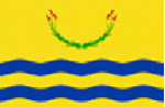
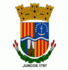
During the 17th century, large parts of the municipality were owned by the Hato Grande de los Delgado (The Delgados' Great Ranch). Another ranch, the Hato del Valenciano, was established and later divided into the Hatillo de los Lirios and the Hatillo de los Juncos. This second one became the village of Juncos in the 18th century and was given the status of a town on August 2, 1797. Reeds, which gave the city its name, feature in the center of its flag and the bottom of its coat of arms. The Hato del Valenciano is remembered in the name of the Río Valenciano, as well as the coat of arms of Valencia featuring in Juncos' coat of arms, in addition to the city's two nicknames of La Ciudad del Valenciano (The Valenciano City) and Los Mulos del Valenciano (The Valenciano's Mules).
Puerto Rico was ceded by Spain in the aftermath of the Spanish–American War under the terms of the Treaty of Paris of 1898 and became a territory of the United States. In 1899, the United States Department of War conducted a census of Puerto Rico finding that the population of Juncos was 8,429.
On September 20, 2017 Hurricane Maria struck Puerto Rico. Juncos had been declared a disaster zone a week earlier when Hurricane Irma made landfall only to be hit again. Destruction to homes and infrastructure was estimated at $25 million. Maria triggered numerous landslides in Juncos with its significant wind and rainfall.
Map - Juncos (Municipio de Juncos)
Map


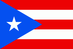
Country - Puerto Rico
 |
 |
Currency / Language
| ISO | Currency | Symbol | Significant figures |
|---|---|---|---|
| USD | United States dollar | $ | 2 |
| ISO | Language |
|---|---|
| EN | English language |
| ES | Spanish language |