Jaluit Atoll (Jaluit Atoll)
Jaluit Atoll (Marshallese: Jālwōj,, or Jālooj, ) is a large coral atoll of 91 islands in the Pacific Ocean and forms a legislative district of the Ralik Chain of the Marshall Islands. Its total land area is 11.34 km2, and it encloses a lagoon with an area of 690 km2. Most of the land area is on the largest islet (motu) of Jaluit (10.4 km²). Jaluit is approximately 220 km southwest of Majuro. Jaluit Atoll is a designated conservation area and Ramsar Wetland.
In 2011 the population of the islands of Jaluit Atoll was 1,788. It was the former administrative seat of the Marshall Islands.
The British merchant vessel Rolla sighted Jaluit in 1803. She had transported convicts from Britain to New South Wales and was on her way to China to find a cargo to take back to Britain.
In 1884, the German Empire claimed Jaluit Atoll, along with the rest of the Marshall Islands, and the Germans established a trading outpost. Jaluit became a German protectorate on September 13, 1886 and had several imperial commissars (Kaiserliche Kommissare):
* 11 May 1894 – March 1898 Georg Irmer (b. 1853 – d. 1931)
* 24 March 1898 – 18 January 1906 Eugen Brandeis (b. 1846 – d. 1919) (acting to 22 February 1900)
* 18 January 1906 – May 1906 Ludwig Kaiser (acting) (b. 1862 – d. 1906)
* 1 April 1906 – 3 October 1914 the governors of German New Guinea; afterwards the jurisdiction was downgraded to district, under a Bezirksamtmann
The island became part of the vast US Naval Base Marshall Islands. After World War I, the island became a part of the South Seas Mandate, a mandated territory of the Empire of Japan, and was the seat of the Japanese administration over the Marshall Islands. Immigrants from Japan numbered several hundred by the 1930s. During World War II the island's Japanese garrison consisted of 1,584 men of the Imperial Japanese Navy and 727 men of the Imperial Japanese Army. The island was bombed on at least five occasions in November and December 1943 by B-24 Liberator bombers of the USAAF 7th Air Force.
Following World War II, Jaluit came under the control of the United States as part of the Trust Territory of the Pacific Islands until the independence of the Marshall Islands in 1986.
Map - Jaluit Atoll (Jaluit Atoll)
Map
Country - Marshall_Islands
 |
 |
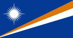
| Flag of the Marshall Islands | |
The country's population of 42,050 people (at the 2021 World Bank Census ) is spread out over five islands and 29 coral atolls, comprising 1,156 individual islands and islets. The capital and largest city is Majuro. It has the largest portion of its territory composed of water of any sovereign state, at 97.87%. The islands share maritime boundaries with Wake Island to the north, Kiribati to the southeast, Nauru to the south, and the Federated States of Micronesia to the west. About 52.3% of Marshall Islanders (27,797 at the 2011 Census) live on Majuro. In 2016, 73.3% of the population were defined as being "urban". The UN also indicates a population density of 295 PD/km2, and its projected 2020 population is 59,190.
Currency / Language
| ISO | Currency | Symbol | Significant figures |
|---|---|---|---|
| USD | United States dollar | $ | 2 |
| ISO | Language |
|---|---|
| EN | English language |
| MH | Marshallese language |


