Imatra
 |
The main employers are pulp and paper manufacturer Stora Enso Oyj, the Town of Imatra, engineering steel manufacturer Ovako Bar Oy Ab, and the Finnish Border Guard. , the total number of employees was 12,423. , 1,868 employees were employed by the Town of Imatra. The town manager of Imatra is Ari Lindeman. The town's nicknames include Imis, Ibiza and Nahkalippis City (Leather Baseball Cap City). Because of the location near the border, Russian tourists are a common sight in the town, and Russian tourism greatly benefits the local business life. Most people shop at Imatra, and Imatra's tax-free sales are the third largest among Finnish cities (only Helsinki and Lappeenranta are ahead).
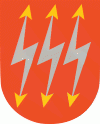
The name of Imatra is believed to have originated from a Pre-Finno-Ugric substrate language. The lightning symbols on Imatra's coat of arms refer to the power plants that were started to be built in the early 1920s in both Tainionskoski and Imatrankoski rapids. The coat of arms was designed by Olof Eriksson, and the Imatra town council approved it on August 9, 1950. The Ministry of the Interior approved the coat of arms for use on October 25 of the same year.
An Art Nouveau or Jugend style castle, currently known as Imatran Valtionhotelli (Imatra State Hotel), was built near the rapids in 1903 as a hotel for tourists from the Russian Imperial capital Saint Petersburg.
During the Continuation War, Carl Gustaf Emil Mannerheim met with Adolf Hitler in secrecy near the town for the former's 75th birthday.
Imatra was founded in 1948 on the territory of three municipalities – Jääski, Ruokolahti and Joutseno. Finland ceded 9% of its territory to the Soviet Union after the Winter War. Jääski lost 85% of its territory and it was decided that a new municipality, Imatra, should be established on the remaining 15% of Jääski and some areas of Ruokolahti and Joutseno. This is why the Imatra coat of arms has three flashes – in honour of those previous municipalities that granted areas to it. It gained its municipal charter in 1971.
Map - Imatra
Map


Country - Finland
 |
 |
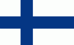
| Flag of Finland | |
Finland was first inhabited around 9000 BC after the Last Glacial Period. The Stone Age introduced several different ceramic styles and cultures. The Bronze Age and Iron Age were characterized by contacts with other cultures in Fennoscandia and the Baltic region. From the late 13th century, Finland became a part of Sweden as a consequence of the Northern Crusades. In 1809, as a result of the Finnish War, Finland became part of the Russian Empire as the autonomous Grand Duchy of Finland, during which Finnish art flourished and the idea of independence began to take hold. In 1906, Finland became the first European state to grant universal suffrage, and the first in the world to give all adult citizens the right to run for public office. After the 1917 Russian Revolution, Finland declared independence from Russia. In 1918, the fledgling state was divided by the Finnish Civil War. During World War II, Finland fought the Soviet Union in the Winter War and the Continuation War, and Nazi Germany in the Lapland War. It subsequently lost parts of its territory, but maintained its independence.
Currency / Language
| ISO | Currency | Symbol | Significant figures |
|---|---|---|---|
| EUR | Euro | € | 2 |
| ISO | Language |
|---|---|
| FI | Finnish language |
| SV | Swedish language |