Haninge Municipality (Haninge Kommun)
 |
Haninge Municipality was formed in 1971 when Västerhaninge and Österhaninge were united.
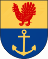
The municipal coat of arms depicts a capercaillie from which the name Haninge is believed to have been derived (the German word hahn means capercaillie), while the anchor symbolizes the naval base in the municipality. The German word usage is supposedly from the old German Hansa traders who operated in the area.
Haninge cherishes its nature, housing the southern parts of the scenic Stockholm archipelago. There are over 3,600 islands, islets and skerries belonging to the municipality, with the three largest islands being Utö, Ornö and Muskö. A car tunnel, the third longest in Sweden, connects Muskö to the mainland. The other two of the islands are reached with passenger and car ferries. Haninge is also an area with access to Tyresta National Park with a surrounding nature reserve. It has been protected to preserve its noted natural values, e.g. one of the largest sections of untouched forest in southern Sweden.
Map - Haninge Municipality (Haninge Kommun)
Map


Country - Sweden
 |
 |
| Flag of Sweden | |
Nature in Sweden is dominated by forests and many lakes, including some of the largest in Europe. Many long rivers run from the Scandes range through the landscape, primarily emptying into the northern tributaries of the Baltic Sea. It has an extensive coastline and most of the population lives near a major body of water. With the country ranging from 55°N to 69°N, the climate of Sweden is diverse due to the length of the country. The usual conditions are mild for the latitudes with a maritime south, continental centre and subarctic north. Snow cover is infrequent in the densely populated south, but reliable in higher latitudes. Furthermore, the rain shadow of the Scandes results in quite dry winters and sunny summers in much of the country.
Currency / Language
| ISO | Currency | Symbol | Significant figures |
|---|---|---|---|
| SEK | Swedish krona | kr | 2 |
| ISO | Language |
|---|---|
| FI | Finnish language |
| SE | Northern Sami |
| SV | Swedish language |