Gustaf III Airport (Gustaf III Airport)
Gustaf III Airport, also known as Saint Barthélemy Airport, Rémy de Haenen Airport, sometimes as St. Jean Airport (Aérodrome de St Jean ), is a public use airport located in the village of St. Jean on the Caribbean island of Saint Barthélemy.
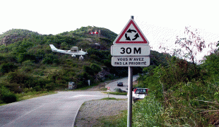
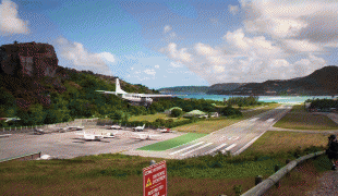
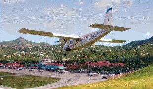
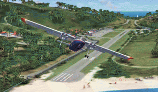
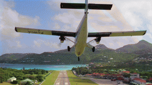
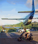
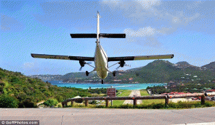
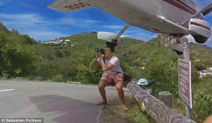
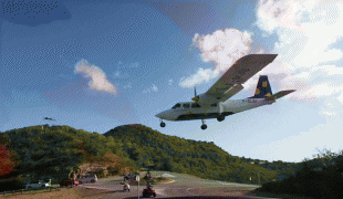
Due to its very short runway, very close proximity to automotive traffic on a nearby road, and the necessity of a license to land at the airport, The History Channel documentary Most Extreme Airports ranked it the third most dangerous airport in the world, behind Toncontín International Airport and Lukla Airport.
Both the airport and the island's main town of Gustavia are named after King Gustav III of Sweden, under whom Sweden obtained the island from France in 1784 (it was sold back to France in 1878). In 1984, the Swedish Minister of Communications, Hans Gustafsson, inaugurated the terminal building of the Gustaf III Airport. In 2015 the airport got the name Aéroport de Saint-Barthélemy-Rémy-de-Haenen, named after Rémy de Haenen, an aviation pioneer and later mayor of Saint Barthélemy.
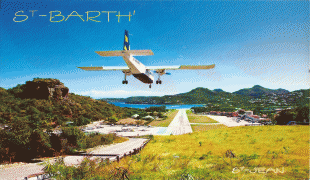
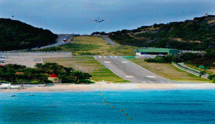
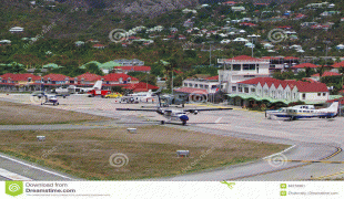
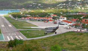
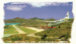
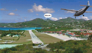
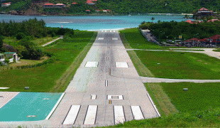
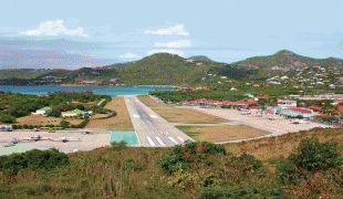
The airport is served by small regional commercial aircraft and charters. Most visiting aircraft carry fewer than twenty passengers, such as the Twin Otter, a common sight throughout the northern West Indies and as a curiosity, the Canadian-built de Havilland Dash 7 is the largest aircraft ever allowed to operate at this airport. The short airstrip is at the base of a gentle slope ending directly on the beach. The arrival descent is extremely steep over the hilltop traffic circle; departing planes fly right over the heads of sunbathers (although small signs advise sunbathers not to lie directly at the end of the runway). The airport is located at the island's second-largest town, St. Jean. The most common aircraft flying in for commercial service are the Pilatus PC-12, Cessna 208B Grand Caravan, de Havilland DHC-6 Twin Otter, and Britten-Norman BN-2 Islander.
Due to its very short runway, very close proximity to automotive traffic on a nearby road, and the necessity of a license to land at the airport, The History Channel documentary Most Extreme Airports ranked it the third most dangerous airport in the world, behind Toncontín International Airport and Lukla Airport.
Both the airport and the island's main town of Gustavia are named after King Gustav III of Sweden, under whom Sweden obtained the island from France in 1784 (it was sold back to France in 1878). In 1984, the Swedish Minister of Communications, Hans Gustafsson, inaugurated the terminal building of the Gustaf III Airport. In 2015 the airport got the name Aéroport de Saint-Barthélemy-Rémy-de-Haenen, named after Rémy de Haenen, an aviation pioneer and later mayor of Saint Barthélemy.
The airport is served by small regional commercial aircraft and charters. Most visiting aircraft carry fewer than twenty passengers, such as the Twin Otter, a common sight throughout the northern West Indies and as a curiosity, the Canadian-built de Havilland Dash 7 is the largest aircraft ever allowed to operate at this airport. The short airstrip is at the base of a gentle slope ending directly on the beach. The arrival descent is extremely steep over the hilltop traffic circle; departing planes fly right over the heads of sunbathers (although small signs advise sunbathers not to lie directly at the end of the runway). The airport is located at the island's second-largest town, St. Jean. The most common aircraft flying in for commercial service are the Pilatus PC-12, Cessna 208B Grand Caravan, de Havilland DHC-6 Twin Otter, and Britten-Norman BN-2 Islander.
Map - Gustaf III Airport (Gustaf III Airport)
Map


Country - Saint_Barthélemy
 |
 |
Saint Barthélemy was for many years a French commune forming part of Guadeloupe, which is an overseas region and department of France. In 2003 the island voted in favour of secession from Guadeloupe to form a separate overseas collectivity (collectivité d'outre-mer, abbreviated to COM) of France. The collectivity is one of four territories among the Leeward Islands in the northeastern Caribbean that make up the French West Indies, along with Saint Martin, Guadeloupe (200 km southeast), and Martinique.
Currency / Language
| ISO | Currency | Symbol | Significant figures |
|---|---|---|---|
| EUR | Euro | € | 2 |
| ISO | Language |
|---|---|
| FR | French language |