Fongafale (Funafuti)
On Fongafale, the Funafuti Kaupule is responsible for approval of the construction of houses or extensions to existing buildings on private land, and the Lands Management Committee is the responsible authority in relation to lands leased by government.
In 1972, Funafuti was in the path of Cyclone Bebe. Cyclone Bebe knocked down 90% of the houses and trees on Fongafale. The storm surge created a wall of coral rubble along the ocean side of Fongafale and Funafala that was about 10 mi long, and about 10 ft to 20 ft thick at the bottom.
Fogafale islet is the location of the main village settlements of Lofeagai, Teone, Fakai Fou, Senala, Alapi, Vaiaku and Kavatoetoe, from the northern to the southern point of the islet respectively which appear as one contiguous urban area.
Vaiaku is the most important neighbourhood; it includes the Vaiaku Lagi Hotel (the only hotel of the country; there are also a few guesthouses), some shops, a fuelpump station, the general post office, and the National Bank of Tuvalu, the nation's only commercial bank. The villages have a surface area of more than 0.65 square kilometres and approximately 4,000 inhabitants.
Map - Fongafale (Funafuti)
Map
Country - Tuvalu
 |
 |
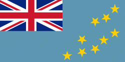
| Flag of Tuvalu | |
The first inhabitants of Tuvalu were Polynesians, according to well-established theories regarding a migration of Polynesians into the Pacific that began about three thousand years ago. Long before European contact with the Pacific islands, Polynesians frequently voyaged by canoe between the islands. Polynesian navigation skills enabled them to make elaborately planned journeys in either double-hulled sailing canoes or outrigger canoes. Scholars believe that the Polynesians spread out from Samoa and Tonga into the Tuvaluan atolls, which then served as a stepping stone for further migration into the Polynesian outliers in Melanesia and Micronesia.
Currency / Language
| ISO | Currency | Symbol | Significant figures |
|---|---|---|---|
| AUD | Australian dollar | $ | 2 |
| ISO | Language |
|---|---|
| EN | English language |
| SM | Samoan language |


