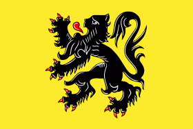
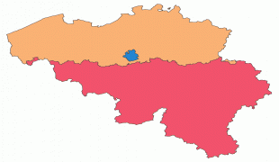
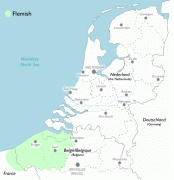
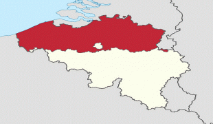
Flanders
 |
 |
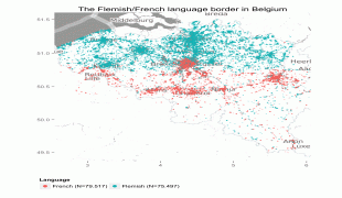
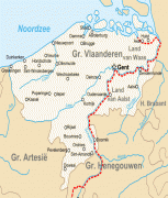
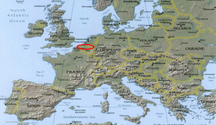
Geographically, Flanders is mainly flat, and has a small section of coast on the North Sea. It borders the French department of Nord to the south-west near the coast, the Dutch provinces of Zeeland, North Brabant and Limburg to the north and east, and the Walloon provinces of Hainaut, Walloon Brabant and Liège to the south. Despite accounting for only 45% of Belgium's territory, it holds the country's largest population, with 6,653,062 (or 57%) out of 11,431,406 Belgian inhabitants living there. Much of Flanders is agriculturally fertile and densely populated at 483 /km2. The Brussels Region is an officially bilingual enclave within the Flemish Region. Flanders also has exclaves of its own: Voeren in the east is between Wallonia and the Netherlands and Baarle-Hertog in the north consists of 22 exclaves surrounded by the Netherlands. Not including Brussels, there are five present-day Flemish provinces: Antwerp, East Flanders, Flemish Brabant, Limburg and West Flanders. The official language is Dutch. Other recognised languages are French and German.
The area of today's Flanders has figured prominently in European history since the Middle Ages. The original County of Flanders stretched around AD 900 from the Strait of Dover to the Scheldt estuary and expanded from there. This county also still corresponds roughly with the modern-day Belgian provinces of West Flanders and East Flanders, along with neighbouring parts of France and the Netherlands. In this period, cities such as Ghent and Bruges of the historic County of Flanders, and later Antwerp of the Duchy of Brabant made it one of the richest and most urbanised parts of Europe, trading, and weaving the wool of neighbouring lands into cloth for both domestic use and export. As a consequence, a very sophisticated culture developed, with impressive achievements in the arts and architecture, rivaling those of northern Italy.
Belgium was one of the centres of the 19th-century Industrial Revolution, but Flanders was at first overtaken by French-speaking Wallonia. In the second half of the 20th century, and due to massive national investments in port infrastructure, Flanders' economy modernised rapidly, and today Flanders and Brussels are much wealthier than Wallonia, being among the wealthiest regions in Europe and the world. In accordance with late 20th century Belgian state reforms, Flanders was made into two political entities: the Flemish Region (Vlaams Gewest) and the Flemish Community (Vlaamse Gemeenschap). These entities were merged, although geographically the Flemish Community, which has a broader cultural mandate, covers Brussels, whereas the Flemish Region does not.
Map - Flanders
Map


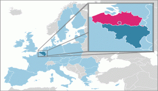
Country - Belgium
 |
 |
| Flag of Belgium | |
Belgium is a sovereign state and a federal constitutional monarchy with a parliamentary system. Its institutional organization is complex and is structured on both regional and linguistic grounds. It is divided into three highly autonomous regions: the Flemish Region (Flanders) in the north, the Walloon Region (Wallonia) in the south, and the Brussels-Capital Region. Brussels is the smallest and most densely populated region, as well as the richest region in terms of GDP per capita. Belgium is also home to two main linguistic communities: the Flemish Community, which constitutes about 60 percent of the population, and the French Community, which constitutes about 40 percent of the population. A small German-speaking Community, numbering around one percent, exists in the East Cantons. The Brussels-Capital Region is officially bilingual in French and Dutch, although French is the dominant language.
Currency / Language
| ISO | Currency | Symbol | Significant figures |
|---|---|---|---|
| EUR | Euro | € | 2 |
| ISO | Language |
|---|---|
| NL | Dutch language |
| FR | French language |
| DE | German language |


