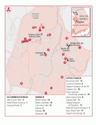
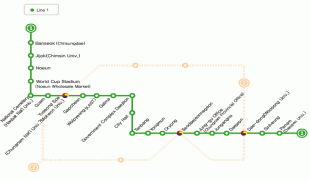
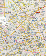
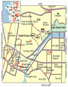
Daejeon
 |
 |
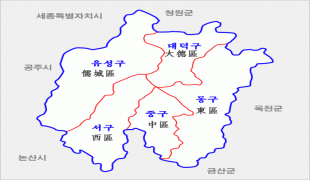
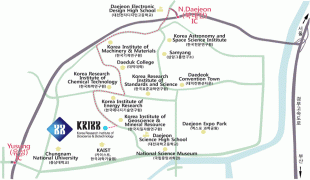
Daejeon (along with Seoul, Gwacheon and Sejong City) are collectively South Korea's administration hubs. The city is home to 23 universities and colleges, including Korea Advanced Institute of Science and Technology (KAIST) and Chungnam National University, as well as government research institutes, and research and development centers for global companies such as Samsung, LG, mostly located in the city's Daedeok Science Town.
Occupied by humans since the Stone Age, Daejeon was historically a collection of small riverside villages. Though the area had varying degrees of strategic importance depending on the period in history, it was largely undeveloped until its use as a rail hub from the early 1900s, during the period of Japanese occupation. From the 1980s, multiple national administrative functions were moved from Seoul to Daejeon, most of which are now located in the Daejeon Government Complex, resulting in another population increase. The city hosted the 1986 Asian Games, the Taejon Expo '93, the International Mathematical Olympiads in 2000, and was elevated to the status of Metropolitan City in 2005.
Daejeon is situated in a lowland valley with three major rivers eventually flowing into the Yellow Sea by way of the Geum river. The city is surrounded by several small mountains, and is located approximately 170 km south of Seoul and 290 km north of Busan, and 70 km east of the Yellow Sea. Daejeon experiences a monsoon-influenced, four-season climate with wet, hot summers and drier, cold winters.
Human beings first settled in the Daejeon region during the Stone Age. It was occupied and in use as strategic military ground in various times by people such as the Usul-gun of Baekje, Bipung-gun of Silla, and the Hoideok-hyeon, Yuseong-hyeon, Deokjin-hyeon, and Jinjam-hyeon. During the Joseon Kingdom period, it remained occupied by the Hoideok-hyeon and Jinjam-hyeon of Gongju Mokha. In 1895, most of the area was made part of Hoideok-gun and Jinjam-gun, excluding some parts that belonged to Gongju-gun.
The Daejeon area was historically known as Hanbat (한밭), a native Korean term for "large field", during the Joseon Dynasty. "Daejeon" simply means the same thing in Hanja. In the 19th century, Daejeon was also known in English as Kung-tsiou.
Historically, Daejeon was a small village without many residents. However, in 1905, the Gyeongbu Railway began operations from Seoul to Busan, opening a station at Daejeon. In 1926 under the rule of the Japanese government, the Honam Railway was built between Mokpo and Daejeon, transforming the latter into a major transportation hub. Because of its location and proximity to means of transportation, Daejeon grew quickly.
As railroads were laid under Japanese rule, an environment friendly to the Japanese was created, and many Japanese began to settle in Daejeon taking advantage of the opportunity. According to 1910 census data, 58%, or more than half of the 4,350 Daejeon population at the time, were Japanese. In 1925, 56% of the 8,861 people in Daejeon were Japanese. Therefore, Daejeon was one of the cities with great cultural influence of Japanese residents. For example, elderly people who experienced Japanese colonial era pronounce '단무지' (Pickled radish, danmuji) as '닥광/단광'(dakgwang/dangwang), '컵' (cup, keob) as '고뿌' (goffu) and '비닐' (vinyl, binil) as '비니루' (binilu). In addition, '우에시다리' (Uesidari), a representative team division game in Daejeon, was also created at this time and is believed to have been derived from the Japanese word '上(うえ, Ue)' meaning 'up' and the Japanese word '下(した, sita)' meaning 'down'.
In 1932, the capital of Chungnam province was moved from Gongju to Daejeon. During the Korean War, the city was the site of an early major conflict: the Battle of Taejon. Also during the war, the mass graves of civilians killed by South Korean police were discovered near Taejon and reported on by Alan Winnington in his famous anti-war leaflet "I Saw Truth in Korea". Embarrassed by the contents of the leaflet, the British government considered having him executed for treason, though instead decided to make him stateless.
Since then, changes have been made to the city's boundaries. Its official names have evolved, as well. Among the boundary modifications include one that effectively made the nearby town of Daedeok a part of the city in 1983. Then, in the late 1980s, Daejeon was elevated to the status of Special City (Jikhalsi), thus became a separate administrative region from Chungcheongnam-do. In 1995, all South Korean Special Cities were again renamed as Metropolitan Cities, which is reflected in the current official name of Daejeon, Daejeon Metropolitan City (대전광역시).
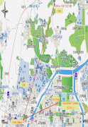
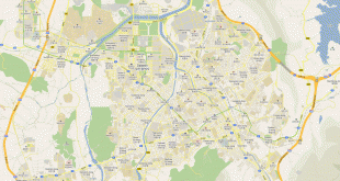
Map - Daejeon
Map


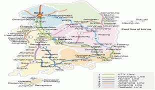
Country - South_Korea
 |
 |
| Flag of South Korea | |
The Korean Peninsula was inhabited as early as the Lower Paleolithic period. Its first kingdom was noted in Chinese records in the early 7th century BCE. Following the unification of the Three Kingdoms of Korea into Silla and Balhae in the late 7th century, Korea was ruled by the Goryeo dynasty (918–1392) and the Joseon dynasty (1392–1897). The succeeding Korean Empire (1897–1910) was annexed in 1910 into the Empire of Japan. Japanese rule ended following Japan's surrender in World War II, after which Korea was divided into two zones; a northern zone occupied by the Soviet Union and a southern zone occupied by the United States. After negotiations on reunification failed, the southern zone became the Republic of Korea in August 1948 while the northern zone became the communist Democratic People's Republic of Korea the following month.
Currency / Language
| ISO | Currency | Symbol | Significant figures |
|---|---|---|---|
| KRW | South Korean won | â‚© | 0 |
| ISO | Language |
|---|---|
| EN | English language |
| KO | Korean language |