Map - Cojedes (state) (Estado Cojedes)

Cojedes  (Estado Cojedes)
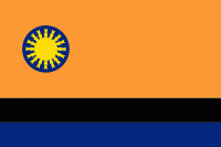
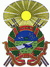
Cojedes State (Estado Cojedes, ) is one of the 23 states of Venezuela. The state capital is San Carlos.

Cojedes State covers a total surface area of 14,800 km2 and, in 2011, had a census population of 323,165.

The name Cojedes, has its origin in the Cariban languages, which means: people of ceramics or people of ceramists. Name that also possesses one of the most important rivers of this federal entity of the plain, (Cojedes River) The same river that is born with the name of Rio Turbio; it passes through Barquisimeto and rises in the northern slope of the Portuguesa mountain range; when it reaches the plain of Barquisimeto it receives the flow of Rio Claro and so goes until it enters the territory of Cojedes, where it is joined by the Tucuragua and the Nirgua.

 
Map - Cojedes  (Estado Cojedes)
Map
Google Earth - Map - Cojedes (state)
Google Earth
Openstreetmap - Map - Cojedes (state)
Openstreetmap
Map - Cojedes  - Esri.WorldImagery
Esri.WorldImagery
Map - Cojedes  - Esri.WorldStreetMap
Esri.WorldStreetMap
Map - Cojedes  - OpenStreetMap.Mapnik
OpenStreetMap.Mapnik
Map - Cojedes  - OpenStreetMap.HOT
OpenStreetMap.HOT
Map - Cojedes  - CartoDB.Positron
CartoDB.Positron
Map - Cojedes  - CartoDB.Voyager
CartoDB.Voyager
Map - Cojedes  - OpenMapSurfer.Roads
OpenMapSurfer.Roads
Map - Cojedes  - Esri.WorldTopoMap
Esri.WorldTopoMap
Map - Cojedes  - Stamen.TonerLite
Stamen.TonerLite
Country - Venezuela
Currency / Language  
ISO Currency Symbol Significant figures
VES Venezuelan bolívar BsS. or Bs. 2
ISO Language
ES Spanish language
Neighbourhood - Country  
  •  Brazil 
  •  Colombia 
  •  Guyana