Albany International Airport (Albany County Airport)
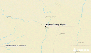
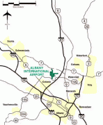
Albany International Airport is 6 mi northwest of Albany, in Albany County, New York, United States. It is owned by the Albany County Airport Authority. ALB covers 1000 acre of land.
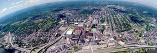
It is an airport of entry in the town of Colonie. It was built on the site of the Shaker settlement about 6 mi north of Albany and stretching north to the hamlet of Verdoy. The airport is a Class Charlie Airspace.
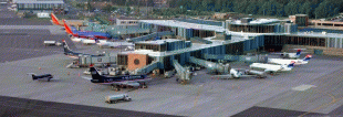
Albany International Airport serves as the major air center for the Capital Region, Northeastern New York, and Western New England. In 2019, the airport handled a total of 1,518,969 passengers, which was a 3.6% increase from 2018. Many airlines serve the airport, with Southwest Airlines having the most presence. They hold 34% of the total airline share at Albany. Along with Southwest Airlines, Albany sees service with many other low-cost carriers, including JetBlue Airways, Allegiant Airlines, and Frontier Airlines. The airport is the fourth largest in New York State.
Albany International was the first and remains the oldest, municipal airport in the United States. In 1908 the airstrip was on a former polo field on Loudonville Road, 3 mi north of the city in the town of Colonie. In 1909 the airport moved to Westerlo Island, in the city of Albany, but at that time was in the town of Bethlehem; the airport was named at this time. The airport was named after Teddy Roosevelt's son, Quentin, a fighter pilot during World War I. A$10,000 prize was established for sustained flight between Albany and New York City; Glenn Curtiss achieved this on May 29, 1910. Other early pioneers of aviation that stopped at this early field were Charles Lindbergh, Amelia Earhart, and James Doolittle.
Mayor John Boyd Thacher II once said "a city without the foresight to build an airport for the new traffic may soon be left behind in the race for competition". He, therefore, decided to build in 1928 a new modern airport on the Shaker site near Albany-Shaker Road in Colonie, not far from the original polo fields used as the first site of the municipal airport. The Shakers not only sold the land used but also loaned the use of tractors and tools.
The early Albany Airport was often closed and threatened with a closure that prompted repeated improvements in the late 1930s and 1940s. The airport was closed from January 1939 until December 1940, when it reopened to traffic during daylight hours only, and then with no restrictions since January 1942. The airport has not been closed (other than for weather and emergency landings) since.
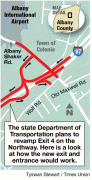
The February 1947 C&GS chart shows three 3500 ft runways aimed at 12, 98, and 133 degrees magnetic. By 1950, the primary runway was up to 5000 ft in length and was hard-surfaced. In 1966 and 1967, the north–south runway was extended to 6000 ft. In the 1980s, the main runway was extended again to the north to 7200 ft. The east/west crosswind runway was also extended eastward to 7200 ft from 5999 ft in the early 2000s, but the landing threshold was maintained, thus the available landing distance was unchanged because of obstructions to the east, but the full length was available for takeoffs to the west. A few years later, another 1300 ft of the runway was added to the north end of the main runway to bring it to its 8500 foot length. The north–south runway gained runway centerline lighting and the north-facing runway added touchdown zone lighting to lower landing minimums - including a category two instrument landing system approach.
ALB was jointly owned and managed by the city and county of Albany until 1960 when Mayor Erastus Corning 2nd ended the city's stake.
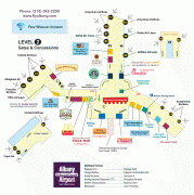
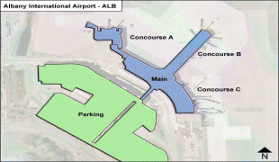
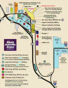
In 1962 a new terminal building opened. A landside building had ticket counters, a coffee shop, and baggage claim on the first floor and a restaurant, offices and viewing area on the second floor. A single-story boarding concourse extended outwards from this building. In 1968 this concourse was widened to allow more concessions and boarding space. The terminal was expanded again in 1979, with the addition of a new two-story building attached diagonally to the northwest. It had boarding gates for Allegheny Airlines on the second floor and baggage carousels on the first floor. The Albany County Airport Authority was created by the county in 1993 with a 40-year lease to operate the airport in 1996. Construction of a new terminal began on May 16, 1996; it opened in June 1998. It was designed by Reynolds, Smith & Hills and Stracher-Roth-Gilmore, and it was built around the existing terminal, most of which was demolished upon its completion. Only the 1979 extension remains from the old terminal building.
In 1999 the Airport Authority began building a 16000 sqft addition to the new terminal for Southwest Airlines' use. The project was completed in 2000 and included the addition of two new dual jet bridges allowing passengers to board and deplane from front and rear doors of the aircraft.
It is an airport of entry in the town of Colonie. It was built on the site of the Shaker settlement about 6 mi north of Albany and stretching north to the hamlet of Verdoy. The airport is a Class Charlie Airspace.
Albany International Airport serves as the major air center for the Capital Region, Northeastern New York, and Western New England. In 2019, the airport handled a total of 1,518,969 passengers, which was a 3.6% increase from 2018. Many airlines serve the airport, with Southwest Airlines having the most presence. They hold 34% of the total airline share at Albany. Along with Southwest Airlines, Albany sees service with many other low-cost carriers, including JetBlue Airways, Allegiant Airlines, and Frontier Airlines. The airport is the fourth largest in New York State.
Albany International was the first and remains the oldest, municipal airport in the United States. In 1908 the airstrip was on a former polo field on Loudonville Road, 3 mi north of the city in the town of Colonie. In 1909 the airport moved to Westerlo Island, in the city of Albany, but at that time was in the town of Bethlehem; the airport was named at this time. The airport was named after Teddy Roosevelt's son, Quentin, a fighter pilot during World War I. A$10,000 prize was established for sustained flight between Albany and New York City; Glenn Curtiss achieved this on May 29, 1910. Other early pioneers of aviation that stopped at this early field were Charles Lindbergh, Amelia Earhart, and James Doolittle.
Mayor John Boyd Thacher II once said "a city without the foresight to build an airport for the new traffic may soon be left behind in the race for competition". He, therefore, decided to build in 1928 a new modern airport on the Shaker site near Albany-Shaker Road in Colonie, not far from the original polo fields used as the first site of the municipal airport. The Shakers not only sold the land used but also loaned the use of tractors and tools.
The early Albany Airport was often closed and threatened with a closure that prompted repeated improvements in the late 1930s and 1940s. The airport was closed from January 1939 until December 1940, when it reopened to traffic during daylight hours only, and then with no restrictions since January 1942. The airport has not been closed (other than for weather and emergency landings) since.
The February 1947 C&GS chart shows three 3500 ft runways aimed at 12, 98, and 133 degrees magnetic. By 1950, the primary runway was up to 5000 ft in length and was hard-surfaced. In 1966 and 1967, the north–south runway was extended to 6000 ft. In the 1980s, the main runway was extended again to the north to 7200 ft. The east/west crosswind runway was also extended eastward to 7200 ft from 5999 ft in the early 2000s, but the landing threshold was maintained, thus the available landing distance was unchanged because of obstructions to the east, but the full length was available for takeoffs to the west. A few years later, another 1300 ft of the runway was added to the north end of the main runway to bring it to its 8500 foot length. The north–south runway gained runway centerline lighting and the north-facing runway added touchdown zone lighting to lower landing minimums - including a category two instrument landing system approach.
ALB was jointly owned and managed by the city and county of Albany until 1960 when Mayor Erastus Corning 2nd ended the city's stake.
In 1962 a new terminal building opened. A landside building had ticket counters, a coffee shop, and baggage claim on the first floor and a restaurant, offices and viewing area on the second floor. A single-story boarding concourse extended outwards from this building. In 1968 this concourse was widened to allow more concessions and boarding space. The terminal was expanded again in 1979, with the addition of a new two-story building attached diagonally to the northwest. It had boarding gates for Allegheny Airlines on the second floor and baggage carousels on the first floor. The Albany County Airport Authority was created by the county in 1993 with a 40-year lease to operate the airport in 1996. Construction of a new terminal began on May 16, 1996; it opened in June 1998. It was designed by Reynolds, Smith & Hills and Stracher-Roth-Gilmore, and it was built around the existing terminal, most of which was demolished upon its completion. Only the 1979 extension remains from the old terminal building.
In 1999 the Airport Authority began building a 16000 sqft addition to the new terminal for Southwest Airlines' use. The project was completed in 2000 and included the addition of two new dual jet bridges allowing passengers to board and deplane from front and rear doors of the aircraft.
| IATA Code | ALB | ICAO Code | KALB | FAA Code | |
|---|---|---|---|---|---|
| Telephone | +1 518 242 2222 | Fax | +1 518 242 2640 | ||
| Home page | Hyperlink |
Map - Albany International Airport (Albany County Airport)
Map


Country - United_States
 |
 |
| Flag of the United States | |
Indigenous peoples have inhabited the Americas for thousands of years. Beginning in 1607, British colonization led to the establishment of the Thirteen Colonies in what is now the Eastern United States. They quarreled with the British Crown over taxation and political representation, leading to the American Revolution and proceeding Revolutionary War. The United States declared independence on July 4, 1776, becoming the first nation-state founded on Enlightenment principles of unalienable natural rights, consent of the governed, and liberal democracy. The country began expanding across North America, spanning the continent by 1848. Sectional division surrounding slavery in the Southern United States led to the secession of the Confederate States of America, which fought the remaining states of the Union during the American Civil War (1861–1865). With the Union's victory and preservation, slavery was abolished nationally by the Thirteenth Amendment.
Currency / Language
| ISO | Currency | Symbol | Significant figures |
|---|---|---|---|
| USD | United States dollar | $ | 2 |
| ISO | Language |
|---|---|
| EN | English language |
| FR | French language |
| ES | Spanish language |