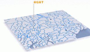
Agat (Agat Municipality)
The village is 10 mi southwest of Hagåtña, with most of the residents ethnic Chamorros, the indigenous people of Guam. Some of Agat's most notable sites are Mount Alifan, the Agat Marina, the Spanish Bridge, and War In The Pacific National Historical Park.
In 1565, the Spanish explorer Miguel López de Legazpi claimed Guam for Spain. Agat was founded between 1680 and 1684, by the Spanish Governor Don Jose Quiroga, as a military garrison for the purpose of controlling the Chamorro people and converting them to Christianity. Many of its first citizens were brought from the internal village of Fina which was destroyed while the Spanish pacified the island. It was one of six such settlements on Guam in the 18th century. During the 1830s, the Spanish Governor, Captain Villalobos, began constructing facilities in Agat planning to make it the island's new capital. Lack of funds prevented him from completing the project.
In 1898, Guam was transferred from Spain to the United States following the Spanish–American War. Under U.S. Naval administration, Agat was incorporated as a township with an American style municipal government.
During World War II, Japan occupied Guam from 1941 to 1944. During the Battle of Guam in 1944, Agat was one of the two landing sites for U.S. Marines. These sites are now part of the War in the Pacific National Historical Park. The old village was destroyed during the invasion. After capturing Guam, the U.S. military constructed a new residential community in Agat for Guam residents made homeless by the war south of the original village.
In August 2021, Gov. Lou Leon Guerrero signed a bill officially changing the name of the village.
Map - Agat (Agat Municipality)
Map


Country - Guam
 |
 |
People born on Guam are American citizens but are politically disenfranchised, having no vote in the United States presidential elections while residing on Guam. Guam delegates to the United States House of Representatives have no vote on the floor. Indigenous Guamanians are the Chamoru, historically known as the Chamorro, who are related to the Austronesian peoples of Malay archipelago, the Philippines, Taiwan, and Polynesia. But unlike most of its neighbors, Chamorro language is not classified as a Micronesian or Polynesian language. Rather, like Palauan, it possibly constitutes an independent branch of the Malayo-Polynesian language family. As of 2022, Guam's population is 168,801. Chamorros are the largest ethnic group, but a minority on the multi-ethnic island. The territory spans 210 mi2 and has a population density of 775 /mi2. The Chamorro people settled the island approximately 3,500 years ago. Portuguese explorer Ferdinand Magellan, while in the service of Spain, was the first European to visit the island on March 6, 1521. Guam was colonized by Spain in 1668. Between the 16th and 18th centuries, Guam was an important stopover for the Spanish Manila Galleons. During the Spanish–American War, the United States captured Guam on June 21, 1898. Under the 1898 Treaty of Paris, Spain ceded Guam to the U.S. effective April 11, 1899.
Currency / Language
| ISO | Currency | Symbol | Significant figures |
|---|---|---|---|
| USD | United States dollar | $ | 2 |
| ISO | Language |
|---|---|
| CH | Chamorro language |
| EN | English language |